A new study from UCLA’s Institute of Transportation Studies is drawing attention to a question that sounds technical but carries enormous stakes for how SB 79 reshapes neighborhoods like Mar Vista. What, exactly, counts as a transit stop? The answer turns out to be far less settled than anyone has assumed.
Every city, county, and regional planning body in California currently maps a transit stop as the precise physical point where a passenger boards or exits a bus, train, or ferry. Under this definition, a stop is just a pinprick on a map. State law then layers housing development incentives onto parcels within a quarter-mile or half-mile radius of that point.
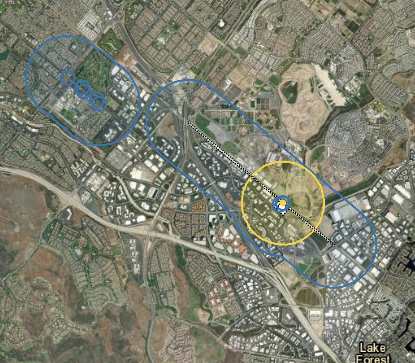
But the UCLA team, whose findings are presented in an interactive story map, argues that state law does not actually require this narrow interpretation. Transit agencies own substantial land around their stations, including parking structures, maintenance yards, bus layover areas, and station plazas. Under what the researchers call the “maximal approach,” the entire agency-owned footprint surrounding a boarding location could reasonably be considered part of the transit stop itself.
That distinction matters because SB 79 ties its upzoning requirements to distance from the transit stop, not from any specific boarding point. If the stop encompasses a broader area, the half-mile radius extends further outward, potentially sweeping in more parcels where taller, denser housing would be permitted or required. According to the research, applying this broader definition statewide could add more than 1.3 million acres of land eligible for housing bonuses, nearly tripling the current total. The UCLA team found no government body currently using this approach, but also found nothing in state law that would prohibit it.
Mar Vista sits in one of the areas where this ambiguity is most consequential. The Expo Line stations at Palms and Culver City, along with planned connections to the future Sepulveda Pass line, define the transit geography of the neighborhood. How those station footprints are drawn, narrowly as a platform edge or more expansively including surrounding agency-owned land, affects which parcels fall within SB 79’s upzoning zone and which remain outside it. The E Line is the example the UCLA researchers used to illustrate the maximal approach in their story map, showing how the eligible housing zone expands meaningfully when Metro-owned property beyond the boarding platform is included.
For residents near these stations, the question determines whether the apartment building on their block, the commercial strip on National, or the parking lots clustered near the station could be legally subject to SB 79’s height and density standards, or whether a narrow reading of the law keeps those parcels in lower-density limbo.
This research arrives as LA is actively working to limit SB 79’s reach rather than expand it. That effort produced a concrete result on Tuesday, when the Los Angeles City Council voted unanimously to implement SB 79 through its most cautious available option. The council approved what planners called Option C1, which upzones 55 single-family and low-density zones near transit to allow four- to sixteen-unit buildings up to four stories. Full SB 79 implementation, which would allow buildings up to nine stories near some stations, is deferred in lower-resource areas, high fire severity zones, and historic districts until 2030, when the city plans to have a local alternative plan in place.
Housing advocates criticized the decision, arguing it falls well short of what the state law was designed to accomplish. As we reported previously, the city’s first implementation roadmap, shaped largely by a motion from Councilmember Traci Park, treated delay and exemption as the default rather than implementation. Tuesday’s vote confirmed that direction. A broad delayed effectuation ordinance, fire zone carve-outs, historic district exclusions, and deferrals in low-resource neighborhoods would together push meaningful SB 79 implementation years into the future, until at least 2030. The City Council’s Planning and Land Use Management Committee reviewed those options earlier this month before the full council acted.
Metro has added another wrinkle. As we covered in January, the agency took an oppose-unless-amended stance on SB 677, a follow-up bill, and floated proposals to exempt Los Angeles County from SB 79 entirely or limit the law to rail lines already in revenue service. Metro’s stated rationale was that SB 79 has made transit politically toxic in cities hostile to new housing density. Advocates warned that gutting SB 79 would push housing farther from transit and undermine Metro’s own ridership and revenue goals for decades.
The UCLA findings are a reminder that the legal framework underlying SB 79 is not as locked down as either its supporters or opponents have assumed. Cities looking to narrow the law’s reach have been probing its exemptions and delay mechanisms for months, and Tuesday’s unanimous vote shows how far that effort can go through entirely legal means. The research suggests there is equal room on the other side, that cities or the state could choose a broader definition of transit stop geography that extends the law’s reach rather than contracting it. As Streetsblog California noted in its coverage of the study, the same ambiguity that lets municipalities shrink their obligations could also unlock significantly more land for development.
In Los Angeles, where the political will has now formally landed on the most limited implementation option available, that potential remains largely theoretical. But if the state housing department or the courts eventually weigh in on how “major transit stop” should be defined, or if Sacramento moves to clarify the statute, the UCLA mapping provides a substantive framework for what a more expansive interpretation would look like in practice.